

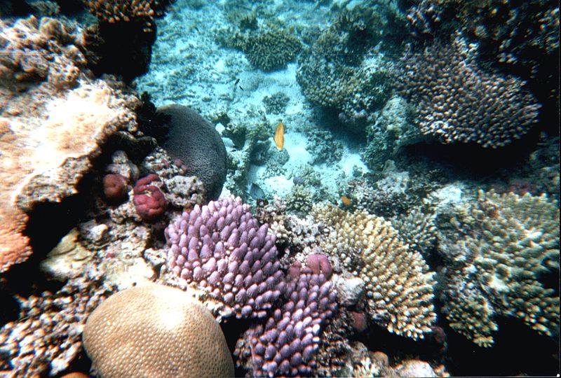


Created by using the latest camera technologies, the Underwater Street View Collection lets you dive deeper into a world most will never have a chance to explore firsthand. Google Street View has partnered with the Catlin Seaview Survey in working to photograph and spread image of ocean reefs from around the world using 360 degree photographs. These images will be used to study the effects of climate change on these delicate ecosystems. By placing these images on Google Street View, users can stroll virtually along the beaches of the Great Barrier Reef, and with one click, plunge themselves underwater to see the beauty of a hidden world.
The partnership with Google is the Catlin Seaside Survey’s method of not only introducing millions of people to these beautiful parts of the world, but also educating them about the effects of temperature change and acidity levels. It has already added images on the Great Barrier Reef and the water around the Hawaiian Islands. In order to capture the images at reefs with deeper depths, like nearly 90 percent of the Great Barrier Reef, the group will use remote operated vehicles with digital cameras. Let’s take a look at some of the technology they employed.
The Camera
The Seaview SVII camera is an incredible piece of kit. The multiple lens camera takes up to 50,000 continuous high-resolution, 360 degree images. Images are taken every three seconds while travelling at 4 km/hour. The photographs are then stitched together so that any internet users with a laptop, tablet or smartphone can seamlessly explore the critters, creatures and colors of the reef. The design of the camera was inspired by the movements of sharks, and it is controlled by a tablet which records GPS data and the angle the photo was taken. The cameras, of which only two exist in the world, are themselves named after a famous oceanographer and a renowned shark photographer.
The Tablet
A crucial component of the camera technology is the mechanism by which it is controlled: a tablet computer. The tablet is in a special underwater case, and it has control over all the operations of the camera. The tablet used by the survey is specially designed to be able to connect to the internet and communicate live with the surface from underwater. The tablet relayed the world’s first underwater internet post in May 2012. The tablet records the exact location of each photograph, so that in the future the crew can return to the same position and retake the images in order to determine the effects of climate change and time on this underwater environment.
The ROV
While the SVII camera is usually accompanied by divers, when diving to the more dangerous depths (in excess of 30 to 100 meters) the Catlin Seaview team uses Remotely Operated Vehicles (ROVs). These vectorized robots can move in any direction and are controlled remotely. These ROVs will take the place of the diver, controlling the direction of the camera and ensuring 360 degree images.
The relationship between the development of technology and safeguarding the environment has not always been a copacetic one. Catlin’s technology demonstrates, however, that mobile gadgets, such as an extremely powerful tablet may be used as tools for safeguarding the natural world. Using cameras, tablets and robots to spread these images of an area at risk shows the development of a mutually beneficial relationship between the natural and man-made world.
These lessons can be applied to our personal lives as well. For example, despite production costs, any notebook, when utilized to its fullest, saves on paper, long-term energy consumption and waste. For instance, if you choose to use your tablet as an e-reader, or even as a university textbook (many of which are now available in electronic form), you are doing your part to conserve the environment. You can download apps to monitor your carbon footprint, and be a part of this effort to safeguard our resilient yet faltering earth.
As the National Oceanic and Atmospheric Administration determined that 95 percent of the ocean is unexplored, the Catlin Survey has set a high bar for themselves, and future exploration in areas including the Caribbean, Indian Ocean and Coral Triangle. While the photos showcase clear crisp waters, fish and algae and also serve as a vivid and stunning entry into the world of diving, they are also meant to convey a message about the fragility of these ecosystems and the ability of technology to aid in spreading the knowledge. So you can see sea turtles, mantra rays and various other sea creatures to your heart’s content, but remember that their futures are in our hands.